Shanghai Urban Planning Exhibition Hall
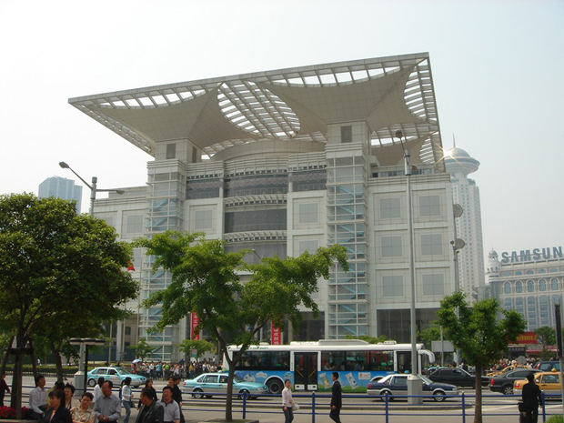
Located at the east part of People's Square (Renmin Square) of Shanghai, Shanghai Urban Planning Exhibition Hall tells people the procedure that Shanghai becomes a famous international city from a small fishing village. The theme of this building is “City, People, Environment and Development”. It exhibits the overall layout of Shanghai, especially the great changes and achievements that have taken place since the reform and opens to the outside world in 1978. Covering an area of 3,600 square meters, it is one of the world's largest showcases of urban development.
Shanghai Urban Planning Exhibition Hall combines tradition with modernity, highlights the use of high technology, and embodies the characteristics of comprehensive, open and public participation. It is a professional venue with rich connotation, complete facilities and comprehensive display of the image of Shanghai. Although its name sounds boring and make people lose interest, but it’s ranked in the top 10 list among over 800 Shanghai attractions on Tripadvisor.
If you curious about how Shanghai has developed so fast and changed into a metropolitan in a short time, you can find the answer in Shanghai Urban Planning Exhibition Hall, and you may also predict the future of this magic city.
Shanghai Urban Planning Exhibition Hall Facts
Construction & Exhibition
The main body of Shanghai Urban Planning Exhibition Hall is a five-story building, which displays Shanghai's development from past, present and future. The main building shape is inspired by the traditional Chinese city gate form, echoing traditional Chinese aesthetic thinking with its central symmetrical structural pattern. TThe top symbolizes the blooming magnolia, the city flower of Shanghai.
Underground & First Floor
The basement or underground was built to appear like a street in old Shanghai, calling back people’s memory to the passing time.
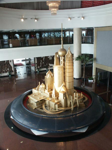
The main feature of the first floor is a large revolving statue of some of Shanghai's most famous buildings.
>> Explore Shanghai Skyline: Famous Skyscrapers
Second Floor
There are some movies and moving models which depict ancient Shanghai in the second floor. Many photos of old Shanghai and the buildings which still exist have photos representing what they looked like when new and what they look like now. They show how the city went from being just a small fishing village to a major world metropolis.
Located on the second floor of the building, the Urban Laboratory, with a professional planning inquiry area on one side and a spatial planning experimental area based on real geographic information data on the other, provides a place for young people to learn about the city. The youngsters can experience the process of urban planning through “role-playing”. After making a planning decision, they can build a module, scan and calculate on the spot, and the computer will immediately evaluate the results.
>> Recommended 17 Days Wonderful China Journey with Shanghai Urban Planning Exhibition Hall
Third & Fourth Floor
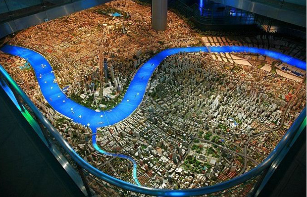
The highlight is on the third floor in Shanghai Urban Planning Exhibition Hall. The “City of Innovation” exhibition hall is located on the 3rd floor above ground. It showcases the Shanghai Pilot Free Trade Zone, the integrated development of the Yangtze River Delta, the Science and Innovation Center, the five new cities and the digital transformation of cities. There is a city model made to a scale of 1/500, which features Shanghai's present. The model went through an entire day cycle from sunrise to night with all of the building's windows illuminated from inside.
The "5D digital immersive city sand table" runs across two exhibition floors, the 3rd and 4th floor above ground. Using the data model from the Shanghai Survey and Mapping Institute for re-modeling, the digital city simulation model will be built for Shanghai with the latest artificial intelligence modeling and other advanced technologies. Not only can we observe the appearance of the city, but we will also create an information model of the city, linking various information related to the building and the city.
The “Eco-City” exhibition hall is located on the 4th floor, and a nice place to visit if you are interested in China Eco-friendly tours. The exhibition space is in light green color, presenting the transformation of Shanghai's urban space and emphasizing the idea of ecological protection. The topography of the river shows the evolution of the Yangtze River estuary over 2,000 years ago, 4,000 years ago, and even 20,000 years ago.
Next to the model was a round room. On the round walls of the rooms was a 360 degree movie taking visitors on a bird's eye trip around the city. The fourth floor displays future transportation, including magnetic levitation, subway, and light-rail trains. The view of the future of Shanghai is presented with high technology such as virtual reality and fantasy-view magic vision. The fifth floor showcases the 2010 World Expo and what is being constructed.
Join Various Activities at Shanghai Urban Planning Exhibition Hall
“Fifteen Minute Community Life Circle”
What is the Fifteen Minute Community Life Circle? A custom-developed multimedia interactive curriculum that takes into account the participation needs of young people aged 7-14, which is divided into three exploration stages: beginner, intermediate and advanced. In the program, participants will take on different roles in the Shanghai community, such as street directors, community residents, and so on. Each character is assigned a task and follows a scripted plot to solve specific problems encountered in the process of building a 15-minute community living circle.
>> Related reading: Elderly Care in Urban and Rural China
"Happy Village”
It helps participants build an overall impression of the countryside, understand the new look of China's countryside in the new era and its future development direction. Participants will play different roles, such as planners, village heads, etc. Students will use familiar building blocks as a medium to build the countryside by themselves. The cave space of ULAB Urban Laboratory will present the planning achievements of the participants.
>> Recommended 13-day Authentic China Tour – Culture, Culinary and Village Real life Experience
How to Get to Shanghai Urban Planning Exhibition?
Since it’s situated in the center of Shanghai, there are many subway can reach it and around. You can take Metro Line 1, 2 or 8 and get off at Renmin Square Station, walk out from Exit 2 and you can easily find Shanghai Urban Planning Exhibition Hall.
Bus 451, 167, 537 and 802 run to Renmin Square Fuzhou Road Station, or Bus 108, 167, 312, 318, 454, 518, 537, 930 and 980 run to Renmin Square Guangdong Road Station. You can get off at these two stops, it’s close to your destination.
If you join Bus Tour in Shanghai, there is a stop at Shanghai Urban Planning Exhibition Hall on both Red line and Green line. You can get it conveniently.
>> Recommended 12 Days China Scenery Tour with Shanghai Urban Planning Exhibition Hall
More Attractions in Shanghai